Making cities safer, healthier and greener with open data
How high-value datasets support safety, public health and climate resilience in regions and cities in Europe
High-value datasets are key public sector datasets that play an important role in delivering social, environmental and economic benefits. Made available free of charge and in machine-readable formats under EU rules, they are central to creating innovative public services and responding to complex challenges.
In a previous data story on urban resilience and efficiency, we saw how regions and cities like Attica, Porto, Herne and Napoli are already turning high-value datasets into concrete services that improve daily life: from wildfire detection to flood forecasting and smarter mobility.
This follow-up story offers new examples of how high-value datasets are helping European cities tackle equally pressing challenges related to public safety, environmental health and climate adaptation and offer proactive, citizen-oriented solutions.
Vilnius: tackling invasive species with data and AI
Vilnius, the European Green Capital for 2025, faced a growing environmental challenge: the spread of Sosnowsky’s hogweed, an invasive and phototoxic plant that poses risks to both ecosystems and public health. Monitoring its expansion across the city required more resources than were available through traditional field inspections.
To address this, the city used drone imagery and AI to identify and map invasive plant areas. The resulting datasets allowed municipal workers to visualise affected zones, calculate their size automatically and track how the plant spreads over time, including projections based on wind patterns.
As a result, the quality and usability of datasets related to green spaces and natural environments improved significantly, and new datasets on invasive species were created. This helped the city target eradication efforts more effectively and plan interventions based on reliable, up-to-date information. Moreover, by making this data publicly available (open), residents can assess the presence of these plants in their area and understand the likelihood of further spread.
Several related high‑value datasets produced through the Vilnius pilot are available on the European Data Portal.
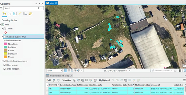
Mapping tool used by municipal workers to plan and monitor eradication work in Vilnius
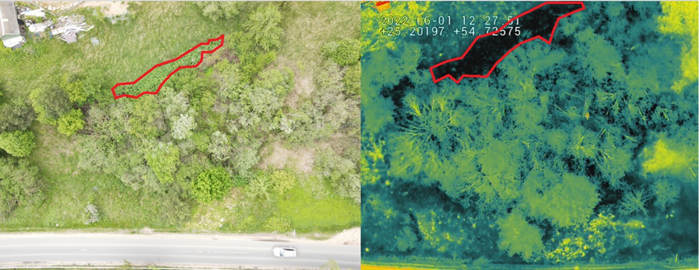
Drone imagery used to detect invasive species: the same area viewed using RGB (left) and thermal (right) cameras
Cartagena, Molina de Segura and Torre Pacheco: safer, healthier urban spaces
Three cities in southern Spain – Cartagena, Molina de Segura and Torre Pacheco – focused on improving urban security, environmental health and climate resilience by bringing together data from multiple domains such as air quality, traffic and crowd density monitoring. This data was integrated for the first time into a single digital portal.
Improving safety in historic city centres
In areas with high pedestrian density, the cities combined data on traffic, air quality, noise levels and crowd movements to support better situational awareness. By integrating these datasets into a single digital platform, authorities were able to monitor risks in real time and shift from responding to incidents after they occur to preventing them earlier.
In parallel, this approach improved the quality and completeness of the underlying datasets from around 30–40 % to full coverage, supporting more informed decisions during busy periods and public events.
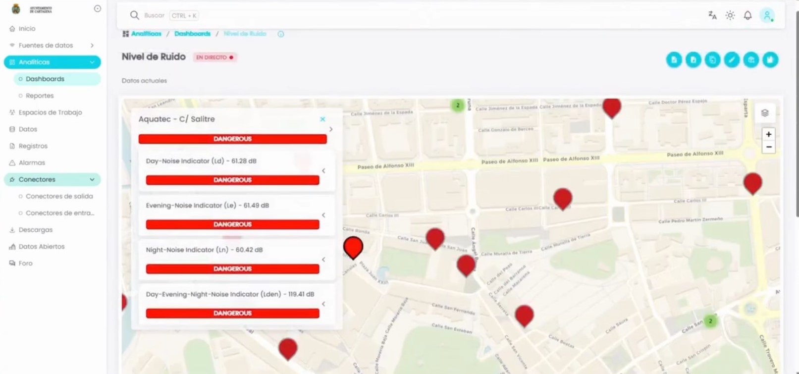
Dashboard of the Municipality of Cartagena showing the levels of noise in different parts of the city
Smarter street lighting for health and efficiency
The cities also addressed the impact of public lighting on energy use and health. Using geolocated data on LED (light-emitting diode) street lights, energy consumption and light intensity, they developed tools to assess where lighting could be adjusted to reduce energy use and limit exposure to blue light.
The initiative helped these cities improve the quality and completeness of their data, providing decision-makers with more reliable information and helping planners make evidence-based choices that improved both efficiency and public well-being.
Responding to heatwaves and urban heat islands
To better manage extreme heat, the cities created publicly accessible maps showing temperature, humidity and air quality in near real time. These tools made it easier to identify heat‑prone areas, support municipal planning and inform citizens during heatwaves.
By improving the quality and accessibility of environmental datasets, the cities were able to turn climate plans into real, on-the-ground action.
Several related high‑value datasets, such as those from Molina de Segura, are now available on the European Data Portal.
From pilots to policy: what cities can learn
The pilots featured in this story were developed as part of the EU‑funded BeOpen project, which supports cities in using high‑value datasets to address urban challenges through open data and digital tools.
Antonio Filograna, Senior Researcher at Engineering Ingegneria Informatica S.p.A. and project coordinator of BeOpen, said: ‘The project helped break down the silos where most data was trapped, unlocking its potential to create innovative digital services that enhance citizens’ quality of life. This journey has been extraordinary, thanks to the incredible people and professionals who collaborated to achieve a shared goal: empowering cities to exploit their data, enabling public and private entities to deliver high-value services to the community.’
Together, these examples show how high-value datasets can help regions and cities protect public health, improve safety and adapt to climate pressures. By turning fragmented data into usable, reliable information, local authorities can deliver services that are more responsive to citizens’ needs and better prepared for future challenges.