Europe’s flood management: Navigating with data
Exploring key datasets and insights for flood monitoring
At the heart of flood risk assessment and management in the European Union is Directive 2007/60/EC, which acknowledges the impact of human activities and climate change on the increasing severity of floods. This legislation strives to mitigate the adverse consequences of flooding through tailored solutions, regional cooperation and the development of comprehensive flood hazard maps. The European Commission further underscores the urgency of addressing these issues with the priorities set in the European Green Deal.
Recent heavy precipitation events in Italy and Slovenia and Mediterranean Storm Daniel serve as reminders of the mounting challenges of flooding. Early in September, Storm Daniel formed in the Mediterranean Sea and hit Greece, Bulgaria, Egypt, Israel and Libya. It was the deadliest Mediterranean tropical-like cyclone in recorded history.
According to the Intergovernmental Panel on Climate Change (a United Nations panel of scientists that study climate change), ‘Human-induced greenhouse gas emissions have led to an increased frequency and/or intensity of some weather and climate extremes since pre-industrial time’. At the same time, one of the reports states, ‘Even relatively small incremental increases in global warming (+ 0.5 °C) cause statistically significant changes in extremes on the global scale and for large regions. In particular, this is the case for temperature extremes, the intensification of heavy precipitation including that associated with tropical cyclones’.
This article delves into the pivotal role of data in flood management, covering risk assessment, preparation for future events and understanding past floods.
The role of data in managing floods
Data forms the backbone of flood risk and damage assessment. Services such as the Copernicus Emergency Management Service provide access to a wealth of Earth observation data, including satellite imagery and remote sensing, which can be harnessed to rapidly assess flood damage.
The integration of real-time data from various sources, including weather stations, river gauges and remote sensing technologies, allows us to predict and prepare for impending flood events. Early warning systems, based on this data, can trigger timely evacuations, secure critical infrastructure and facilitate resource allocation, ultimately saving lives and reducing the social and economic impact of floods.
By analysing historical flood data, we gain valuable insights into the patterns, frequency and severity of floods in a region. This information helps to identify flood-prone areas, enabling authorities to make informed decisions about land-use planning and infrastructure development. Historical flood data also offers critical lessons in understanding and learning from past flood events. By studying how past communities coped with floods and the subsequent recovery processes, we can refine disaster management strategies and improve preparedness.
Using Copernicus data to assess flood damage
One way to monitor the consequences of those events is through the satellite data provided by the Copernicus Emergency Management Service, which offers geospatial information within a few hours or days’ notice, along with risk and recovery mapping and early damage estimates.
Information from Copernicus, as provided by the program’s satellites, falls under the orthoimagery theme of the infrastructure for spatial information in Europe directive (Inspire). This theme encompasses georeferenced image data of the Earth’s surface, gathered from either satellite or airborne sensors. The data is also part of the high-value datasets covered in previous data stories. High-value datasets are a group of datasets defined by EU law based on their potential to provide essential benefits to society, the environment and the economy.
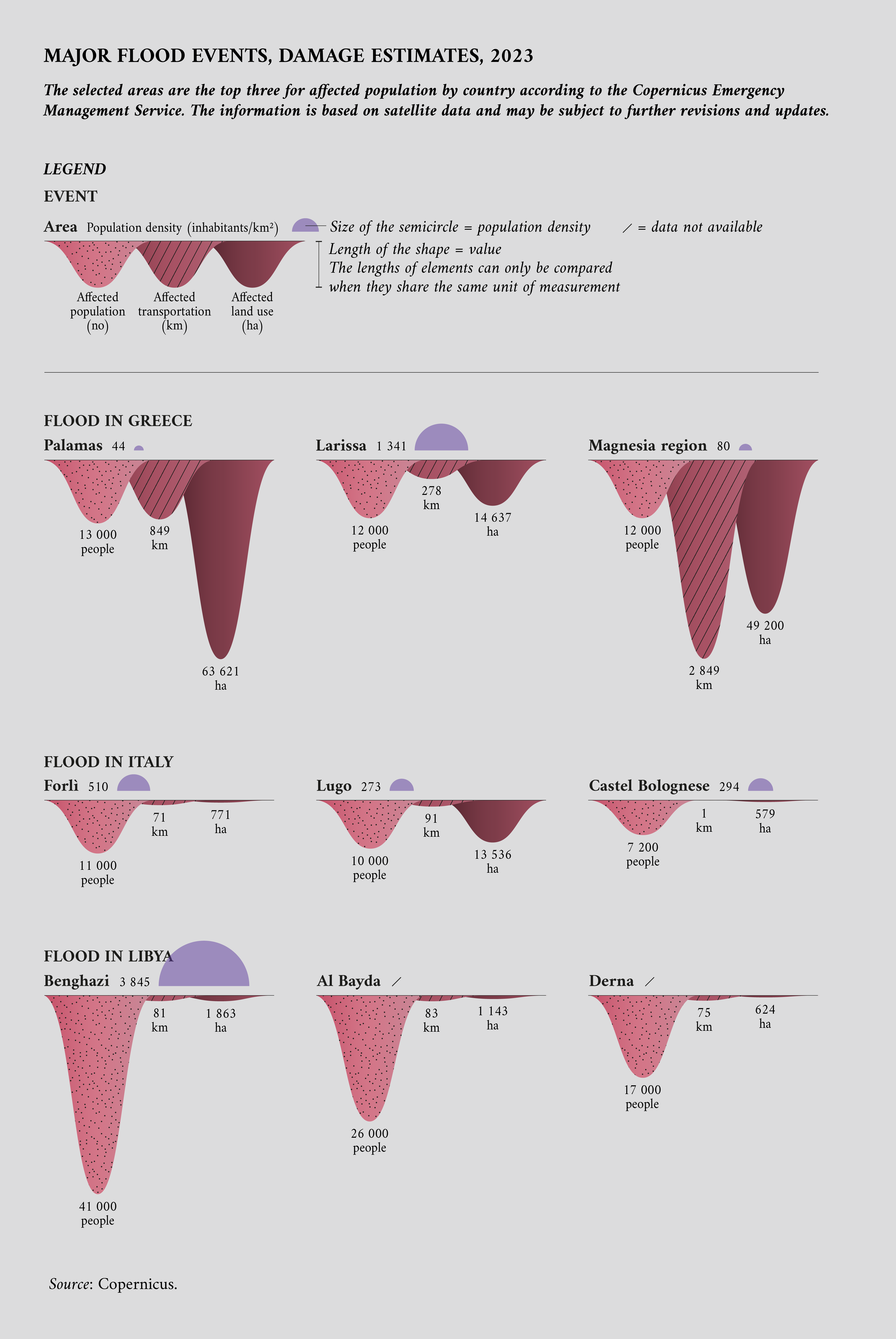
As the following visualisation shows, the Copernicus Emergency Management Service was activated for major flood events in Italy and Greece in 2023. The mapping capabilities are not limited to EU territory, and when deemed appropriate they can be used to monitor other areas too, as was the case for Storm Daniel in Libya. The visualisation highlights the estimated damage to the area’s transportation system and land use, and the number of people affected by the flood events in that area.

Mapping areas at risk of flooding in Europe
To map flood risks at the European level, it is possible to use data provided by the European Environment Agency (EEA). This kind of information enables efficient disaster preparedness and response, allowing authorities to allocate resources and plan evacuation strategies effectively. Such data aids in the development of flood risk assessment and management strategies, which are crucial for minimising the impact of floods on communities, infrastructure and the economy. What’s more, Europe-wide flood data promotes cross-border cooperation and information sharing, which is essential in a region where rivers often flow through multiple countries. Additionally, it supports climate adaptation efforts by providing a comprehensive understanding of changing flood patterns in the face of climate change.
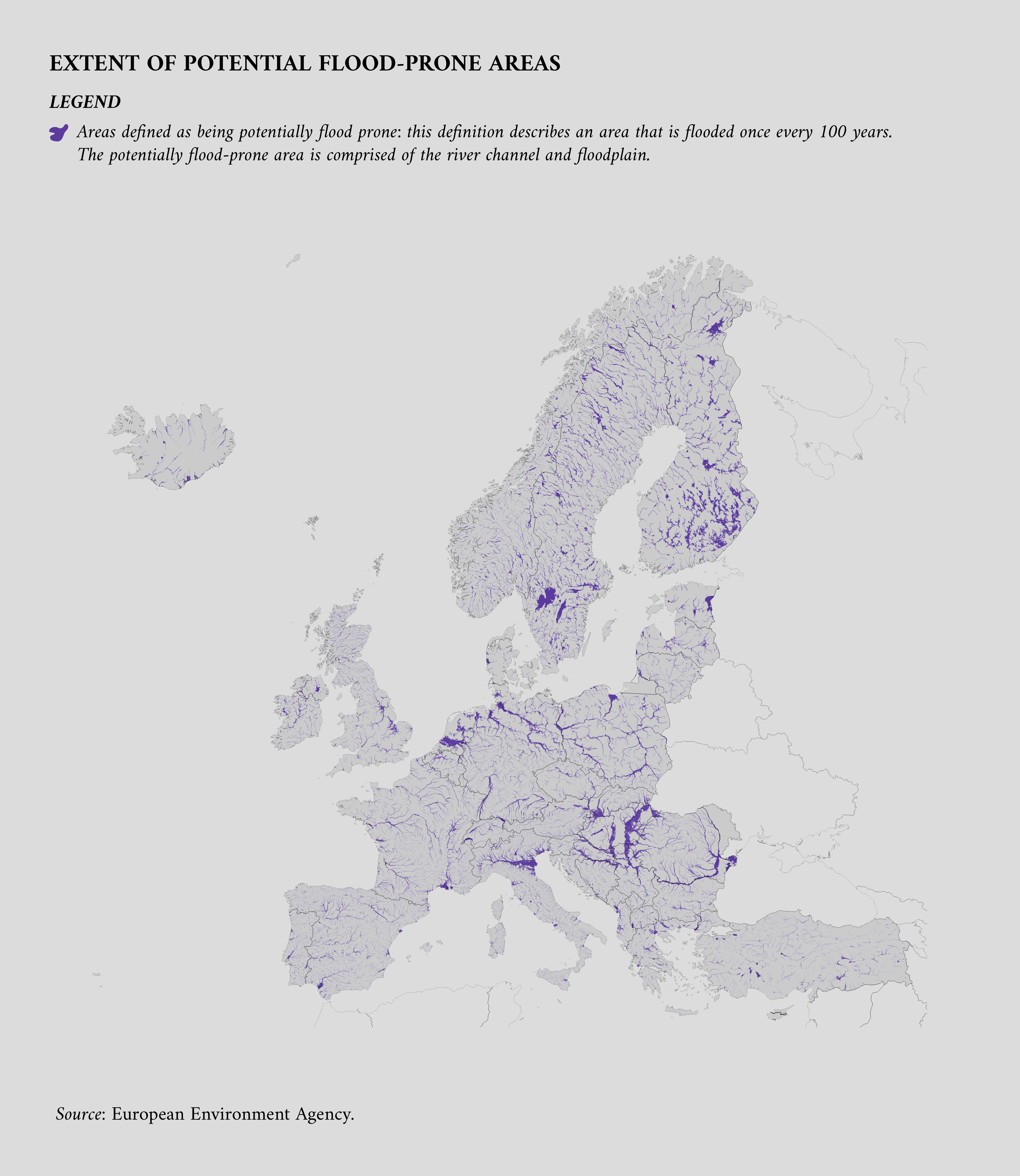
The following visualisation explores flood risk data in Europe. According to the EEA, the data ‘delineates the area that is flooded once every 100 years, i.e. the probability of flooding is 1 % assuming that flooding is unrestricted. The potential flood prone area is comprised of the river channel and floodplain’.

Real-time data on water levels
Continuous recordings of water levels from hydrometric stations serve as a critical basis for flood understanding and management. These measurements are consistently collected by equipped monitoring stations, such as those in the hydrometric network of the Office of Public Works in Ireland, and offer an accurate and complete dataset.
This information is indispensable for flood prediction and management as it allows authorities to track river and water body behaviour in real time. It also aids in assessing drought conditions, managing water resources and ensuring the safety of infrastructure such as bridges and dams. Real-time water level data is invaluable for early warning systems, helping to protect communities and reduce the risks associated with extreme weather events and changing hydrological conditions. Furthermore, the availability of daily, weekly and monthly files allows for trend analysis and long-term planning, making it an essential tool for effective water resource management.
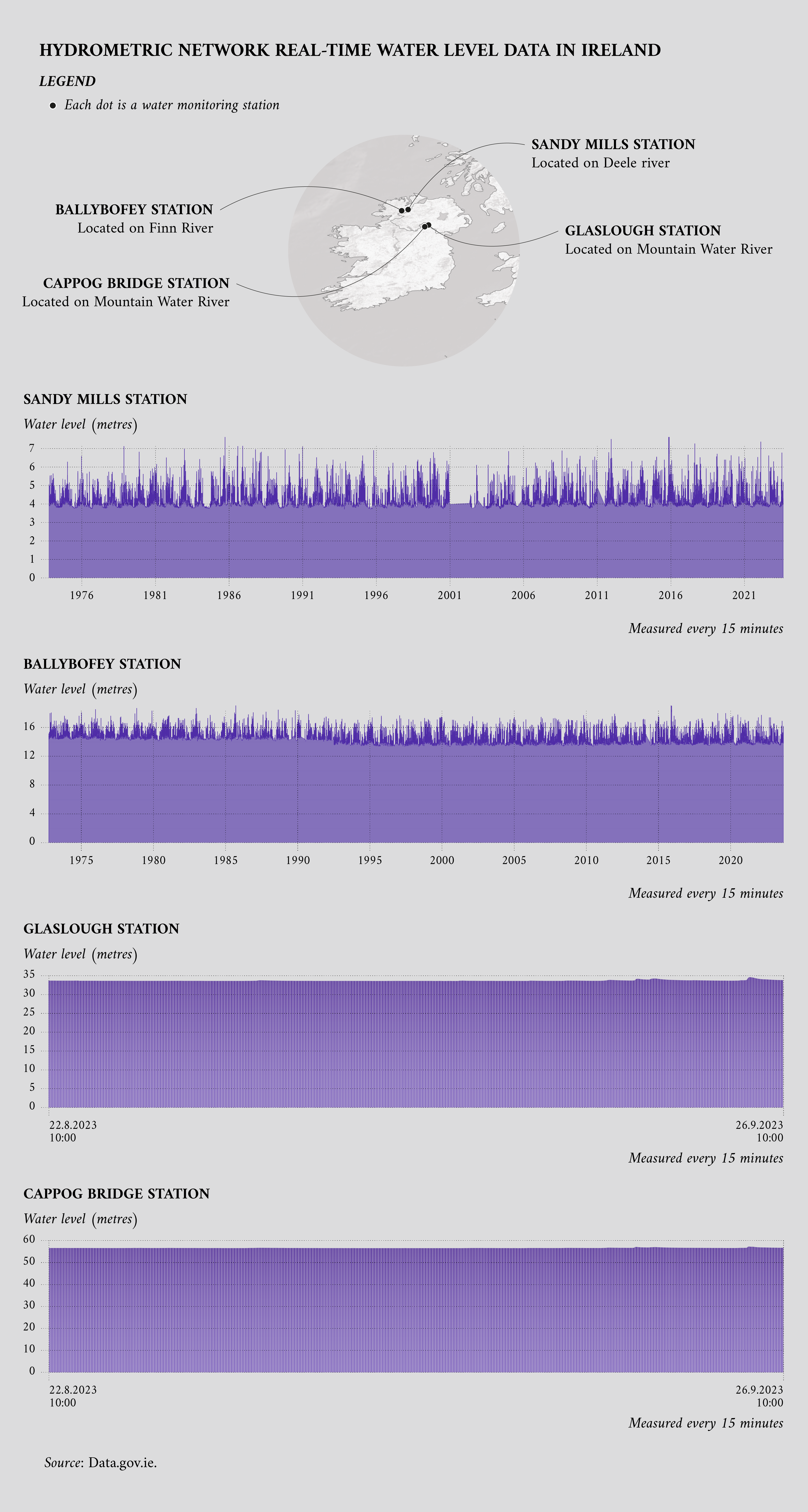
The following visualisation shows water levels recorded every 15 minutes by four monitoring stations (Sandy Mills, Ballybofey, Glaslough and Cappog Bridge) along with their positions. Some of those stations have been monitoring water levels for decades, which also appears in the visualisation. In addition to water level information, Irish authorities make available data about the monitoring stations, including their exact locations, in a JSON file.
The monitoring stations mentioned are components of an expansive network dedicated to flood monitoring. This extensive infrastructure is not unique to any single country. Many nations maintain a broad array of these stations, strategically placed in various locations such as seas and rivers.

Using data.europa.eu for historical research about floods
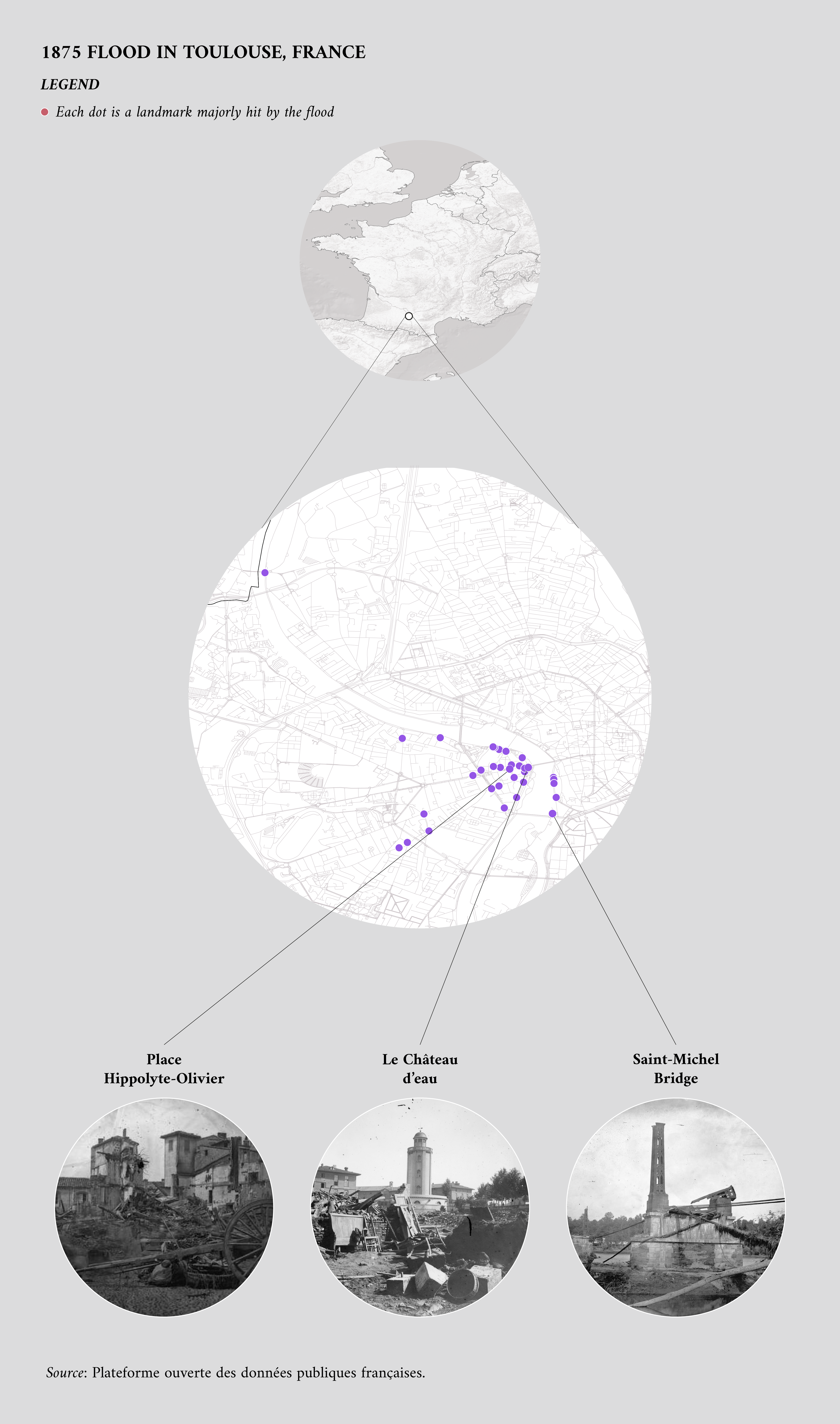
Historical flood data can provide critical insights into past events. On 23 June 1875, the Garonne River, a major waterway in southwestern France, flooded the city of Toulouse. The disaster resulted in extensive damage, including the ruin of around 1 400 homes and the collapse of all the city’s bridges, save for one.
In the aftermath of the 1875 Toulouse flood, significant changes were made to the city’s building regulations to mitigate the impact of future floods. Construction or reconstruction permits would only be granted under specific conditions aimed at enhancing the structural integrity of the buildings.
The data.europa.eu portal supports research into this event, offering a dataset that includes information such as the geographical coordinates of areas hit by the flood, their addresses and links to historical images of the event.
The following visualisation depicts the areas most affected by the 1875 Toulouse flood, along with historical photos showcasing the damage at selected sites.

Exploring additional flood data sources
In addition to data.europa.eu datasets on flooding, numerous other websites from official EU bodies offer valuable resources for flood-related information:
-
The hydrography section of the 'Inspire' geoportal: houses many datasets concerning floods for several EU Member States;
-
European Environment Agency: provides news, indicators and data about floods, such as the river flood index, which is ‘relevant to hydrological applications, transport, and disaster risk management’ and is ‘based on 50-year flood recurrence values based on maximum river discharge values for the 50-year return period’;
-
The European Flood Awareness System: supports preparatory measures before major flood events strike, particularly in large transnational river basins and throughout Europe in general, and offers a live map of flood events and data access to some of its services;
-
Joint Research Centre: includes work concerning preparedness (early warning, monitoring and prevention measures) and response to floods;
-
European Climate and Health Observatory: offers several indicators about climate change and its impact on people, including an estimate of fatalities associated with floods since 1980;
-
The Copernicus Emergency Management Service: also covers earthquakes, fires and other humanitarian crises.
Methodological notes
The areas presented in the first visualisation were selected among the largest floods that have occurred since the spring of 2023. For each flood event, the three cities with the largest affected populations were chosen. Due to the ongoing civil war in Libya, information about its cities serves only as a rough estimate.
Download the data visualisations presented in this article and the data behind them.
Article by Davide Mancino
Data visualisations by Federica Fragapane
