Satellite data in action: Key applications of the EU space programme
Open data from satellites to monitor climate change, enable navigation systems and enhance high-speed connectivity
Space technology plays a crucial role in our daily lives, contributing to a digital, green and resilient future. Satellites provide vital data and services, including weather forecasts, broadband internet access, GPS navigation and support in areas like agriculture, crisis response and climate change mitigation. In line with the EU’s ambitious plans for environmental and digital transformation laid out in the Green Deal and Digital Decade, the EU Space Programme ensures we have the data we need to tackle these challenges.
The EU Space Programme covers a wide range of activities, including earth observation, satellite navigation, connectivity and space research and innovation. This comprehensive programme revolves around three main components: (1) Copernicus, the EU’s earth observation system; (2) Galileo, a global satellite navigation and positioning system; and (3) Egnos, an aviation, maritime and land-based navigation precision system. Moreover, in February 2022, the EU proposed two new space policy initiatives: the EU Space-Based Secure Connectivity System (2023-2027), aiming to ensure satellite communication and fast internet connection across Europe; and Space Traffic Management to establish standards and regulations for safe and sustainable space use.
The EU Space Programme collects, provides and relies on satellite data, including earth observations, environmental monitoring, meteorology, geospatial information and mobility data. Such data is generally classified as high-value data as it provides important benefits for society, the environment and the economy. Recognising their importance, the EU is committed to making these datasets increasingly accessible by making them open and free.
This data story uses open data to illustrate the breadth of information derived from satellites and the multitude of systems powered by satellite data. In addition, it dives into how satellite data supports navigation systems, enables high-speed connectivity and helps us track climate change.
Satellite data on climate change
Satellite data has transformed environmental monitoring, providing a more comprehensive foundation for policymaking and enhancing overall environmental management. Previously, measurements were primarily conducted at ground level, leading to inconsistencies as data was interpolated to create a comprehensive overview. In contrast, earth observation satellites offer a panoramic perspective, capturing detailed snapshots of vast regions in a regular, uniform and instantaneous manner.
Copernicus is the EU’s earth observation programme and serves as the primary global provider of extensive space data. Copernicus retrieves satellite data which undergoes complex climate modelling processes and is translated into tangible, understandable indicators. These are the climate indicators, which showcase the long-term evolution of key variables crucial for assessing global and regional climate trends. The indicators are regularly updated and featured in the annual European State of the Climate report.
Figure 1 provides a snapshot of the key climate indicators included in the European State of the Climate report. Open data from satellites shows that surface air temperature in Europe has surged by 2.3˚ C over the past 173 years, while sea temperatures have risen by 1˚ C in the same time period. Moreover, sea levels are rising at a rate of around 2-4 mm per year, while CH4 greenhouse gas (GHG) emissions have increased by 10 parts per billion between 2010-2023 and glaciers shrunk by 850 km3 between 1976-2023. You can check what other key indicators inform decision-making processes at the EU level here.
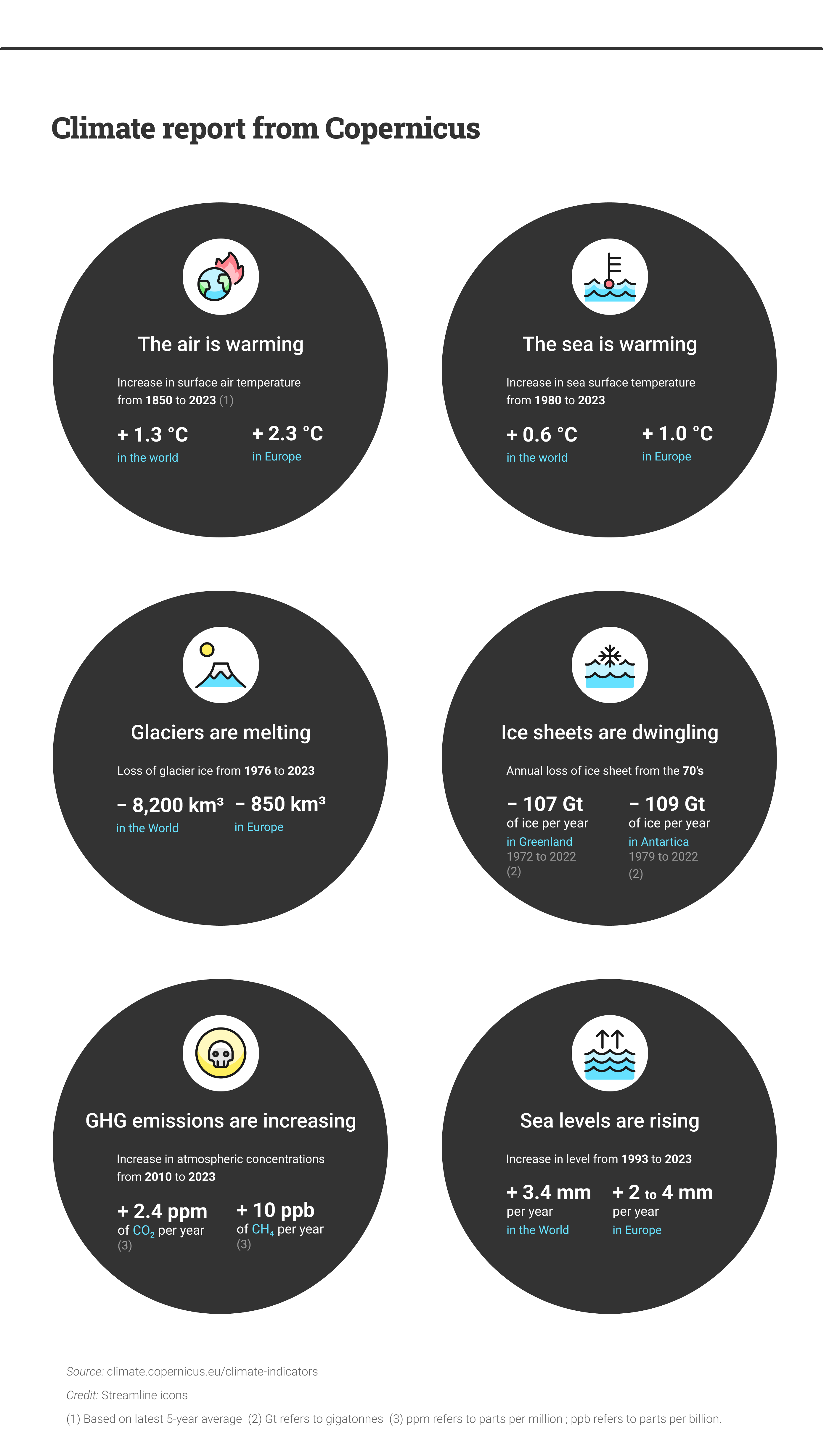
Figure 1: Key climate indicators provided by Copernicus in the European State of Climate report (Source: climate.copernicus.eu)
Satellite data for navigation systems
Satellite navigation stands as another pivotal application enabled by satellites. European satellites are providing users with global positioning, navigation and timing information. More specifically, Galileo serves as the EU’s global satellite navigation and positioning system, offering positioning accuracy to within 20 cm.
Figure 2 provides an overview of Galileo-compatible devices, showcasing a multitude of applications across various sectors. In transportation, for instance, Galileo plays a vital role in maritime, railway, air and road navigation. Moreover, Galileo extends its positioning capabilities to mobile devices, with over 2.5 billion smartphones being Galileo-enabled by the end of 2023.
Satellite data also revolutionises specific industries like agriculture, where precision farming enables European farmers to increase productivity and minimise environmental impact. Furthermore, Galileo’s search and rescue service significantly reduces response times in crises, decreasing the time to locate individuals lost at sea or in the mountains from 3 hours to just 10 minutes. Notably, Galileo plays a central role in the EU’s eCall initiative, wherein all new car and light van models sold in the EU since March 2018 must be equipped with eCall devices that automatically alert rescue services in the event of an accident. Explore the plethora of applications powered by Galileo data here!
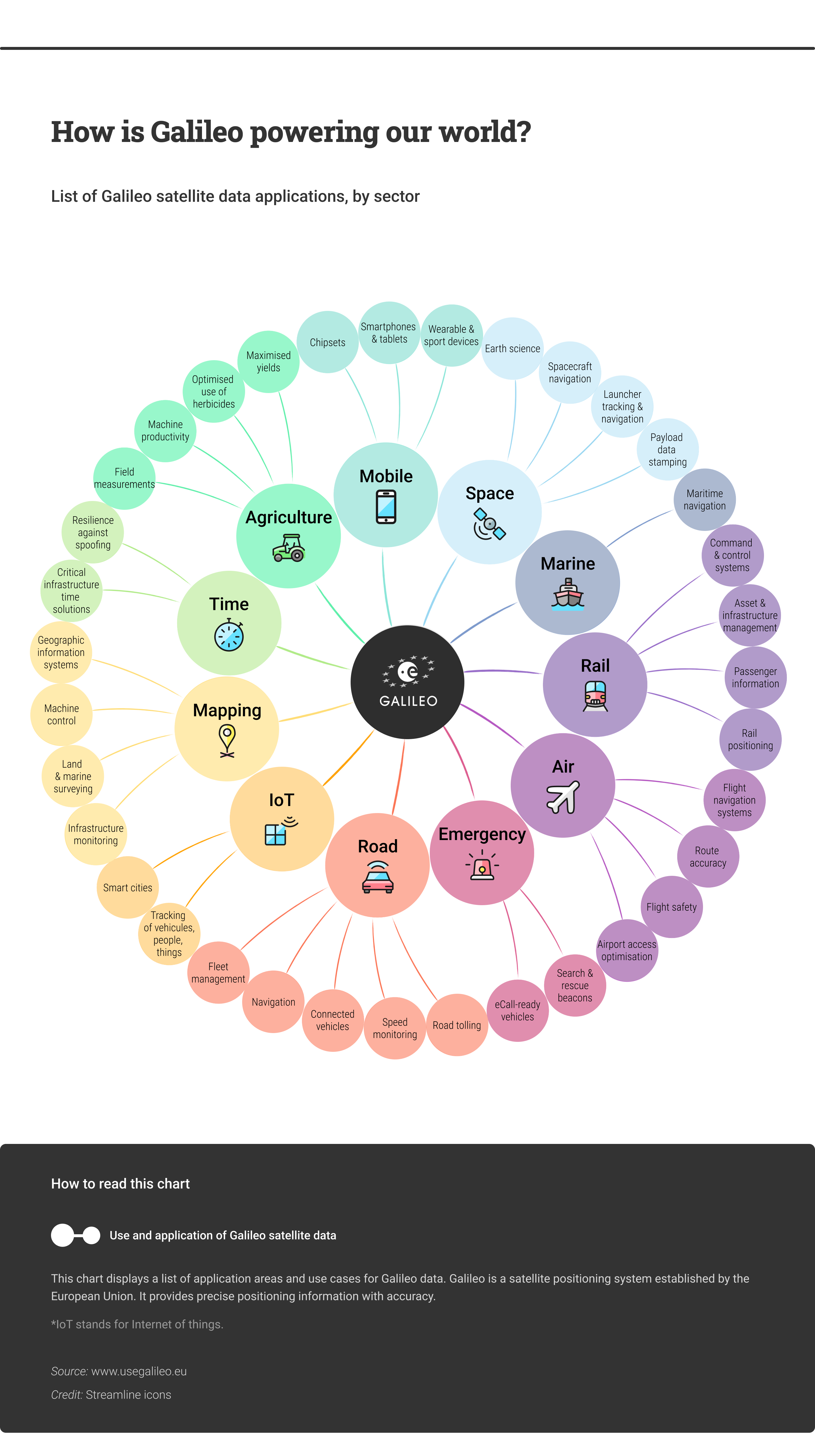
Figure 2: The different applications of satellite data coming from Galileo (Source: usegalileo.eu)
Satellite data for high-speed internet connectivity
One of the primary goals of the EU Space-Based Secure Connectivity System is to ‘ensure high-speed internet broadband to address connectivity dead zones.’ This multiorbital system is designed to guarantee the long-term availability of reliable, secure and cost-effective satellite communication services on a global scale and eliminate communication dead zones.
Open data offers insights into the current state of internet connectivity across EU Member States from 2013 to 2021. The data reveals diverse trends, with some countries experiencing rapid growth, such as Germany, Ireland and the Netherlands, while others exhibit a fast but more gradual increase, like Bulgaria, Spain, France and Romania. Remarkably, Denmark, Luxembourg and Malta emerge as top performers, with nearly all households enjoying access to high-speed connectivity. Overall, the EU has seen a steady rise in connectivity, with approximately 75% of households now equipped with high-capacity network connections. Explore your country’s internet access status further here!
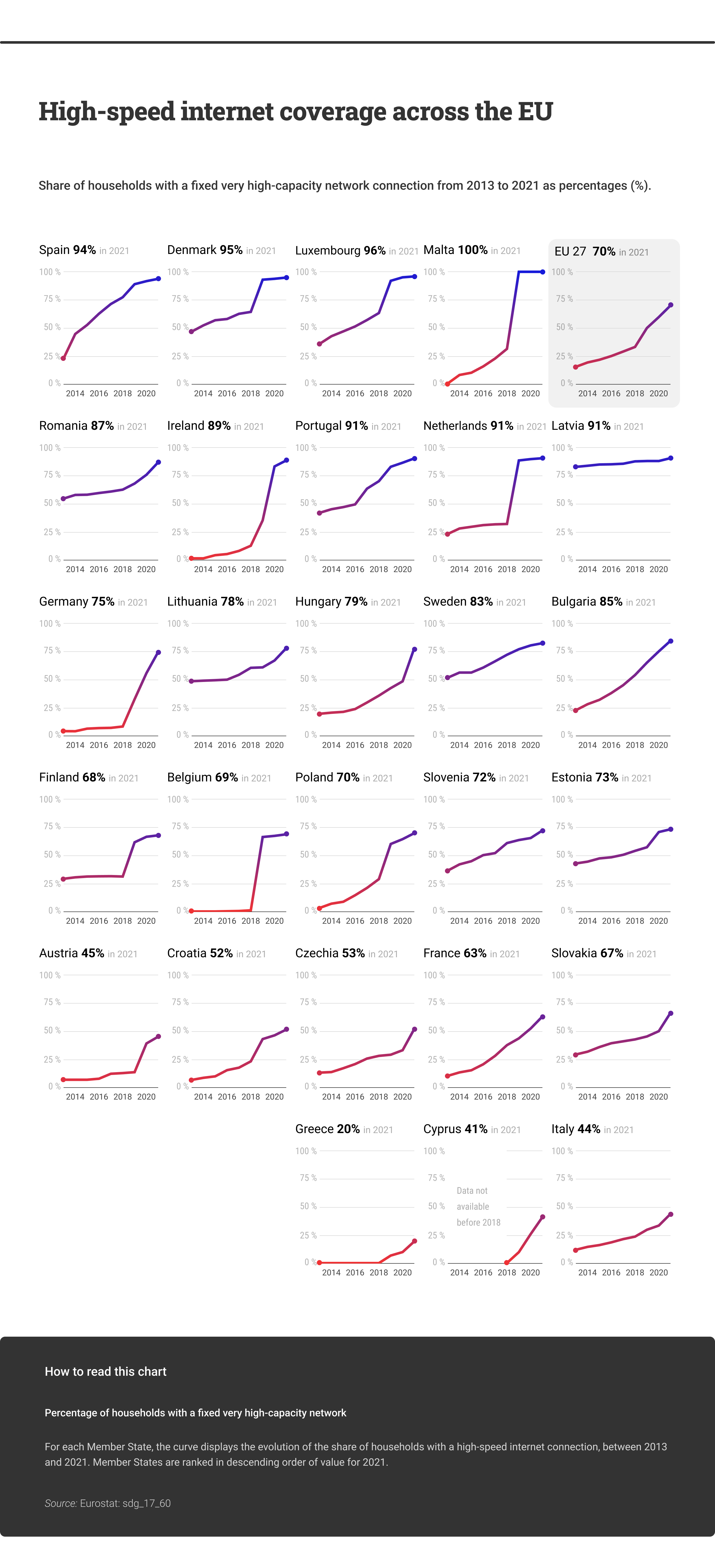
Figure 3: High-speed connectivity across Member States (Source: data.europa.eu/Eurostat)
Conclusion
This data story showed the importance of satellite data, and of the EU Space Programme broadly, in our daily lives. The three visualisations highlighted how satellite data guides policymaking on crucial issues such as climate change, how it allows us to use GPS and enables our connectivity. As we navigate towards a more connected and sustainable future, harnessing the power of open data becomes crucial in enabling informed decision-making. Do you want to explore other applications of satellite data? You can access numerous open datasets on data.europa.eu. Remain updated on our upcoming data stories and webinars by subscribing to our newsletter and following data.europa.eu on social media.