A new era of urban resilience and efficiency
How high-value datasets help European cities and regions improve public services and everyday life
High-value datasets are key public sector datasets that play a crucial role in delivering social, environmental and economic benefits. In line with EU regulations, they are available for free, in machine-readable formats, and are central to creating innovative public services across Europe.
Several European cities are now showing how these datasets can be used to tackle urban challenges such as wildfires, road maintenance, emergency response and sustainable mobility. This data story highlights how cities and regions like Attica (Greece), Herne (Germany), Napoli (Italy) and Porto (Portugal) are turning open data into real-world solutions that improve citizens’ daily lives.
Attica: a shield against wildfires
Every summer, the capital region of Attica in Greece faces a growing risk of wildfires. Traditional fire monitoring relied on static risk assessments and limited public involvement. With the help of open data and digital tools, local authorities introduced a real-time alert system that uses crowdsourced reports, social media posts, satellite data from Copernicusand fire data from the European forest fire information system.
The transition from a top-down approach to citizen-driven monitoring marks a major shift. With data quality scores increasing from 34–39 % to over 85–90 %, this system has dramatically improved the quality and responsiveness of fire detection. By integrating data on nitrogen dioxide levels and real-time social media activity, the system has reduced false alarms and enabled earlier intervention.
The high-value dataset and other related datasets used in Attica are available on the European Data Portal.
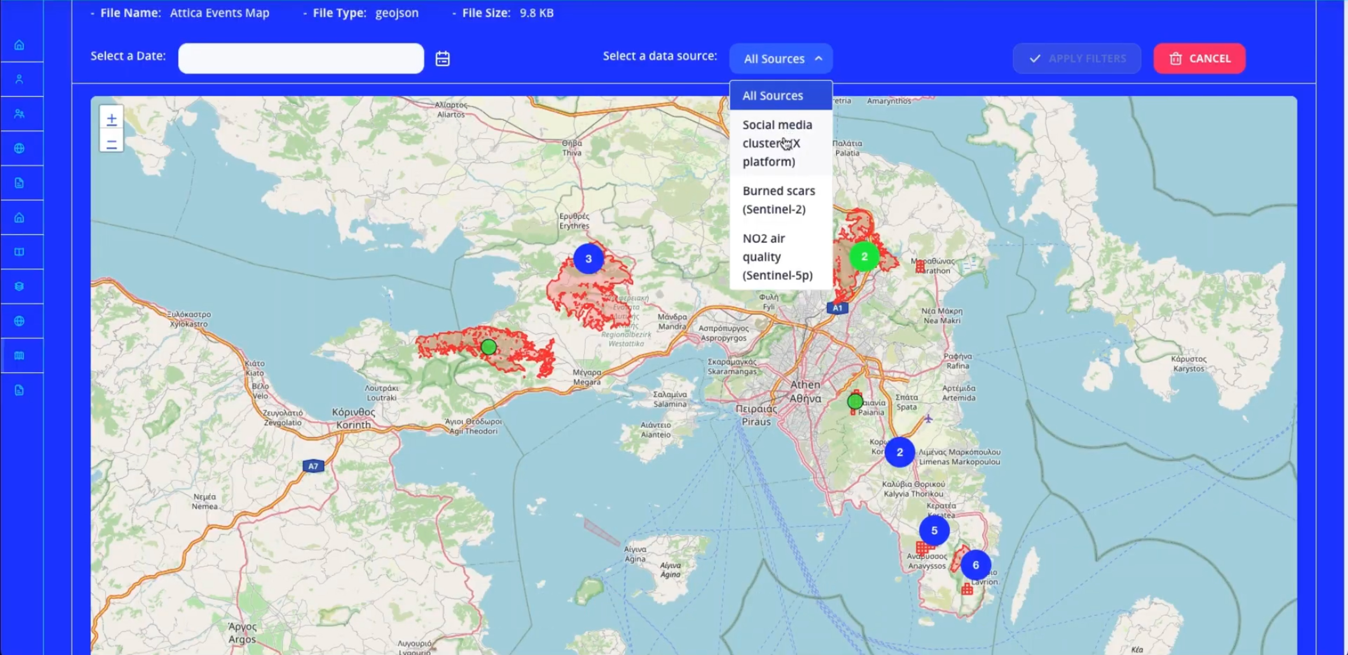
Figure 1: Interactive wildfire detection map in Attica, Greece
The system combines real-time inputs from satellite scans, data on nitrogen dioxide levels, social media posts and citizen reports to pinpoint fire events and guide rapid response.
Herne: smarter roads and safer events
Herne, a city in North Rhine Westphalia, Germany, with an extensive road network, struggled with a lack of real-time data and inefficient traditional maintenance methods, leading to delayed repairs and high costs. By equipping city vehicles with cameras and sensors, authorities used artificial intelligence to detect and classify road damage in real time. This has improved road condition data quality and completeness from only 22 % to 100 %.
The same concept was used to improve crowd safety during major public events like the Cranger Kirmes fair. Using radar sensors, parking applications and artificial-intelligence-powered crowd density cameras, city officials could forecast crowd flows and respond quickly to security risks.
Herne has made several of its high-value datasets publicly available, supporting transparency and reuse.
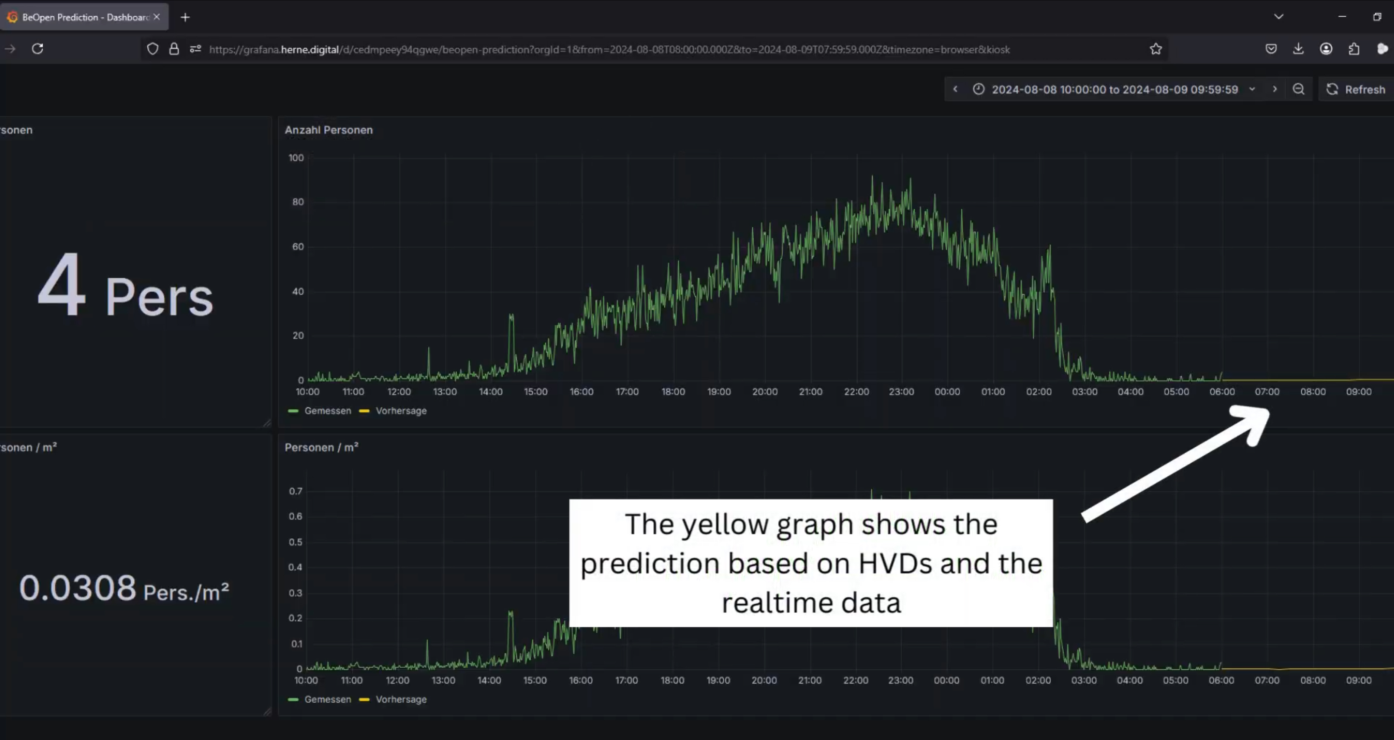
Figure 2: Real-time crowd prediction in Herne, Germany
The system uses high-value datasets and live data to forecast crowd density during large public events, improving safety and emergency response planning.
Napoli: improving mobility and green space data
Napoli tackled the challenge of fragmented data around shared mobility (such as bike rentals and car sharing) and green infrastructure. The city adopted a new system to standardise, validate and publish its data, including Earth observation datasets for soil temperature and green adaptation.
This has helped the city map mobility hubs, cycle paths and areas for environmental improvement while building internal capacity around EU-compliant data practices.
Several high-value datasets from Napoli are available on the European Data Portal.
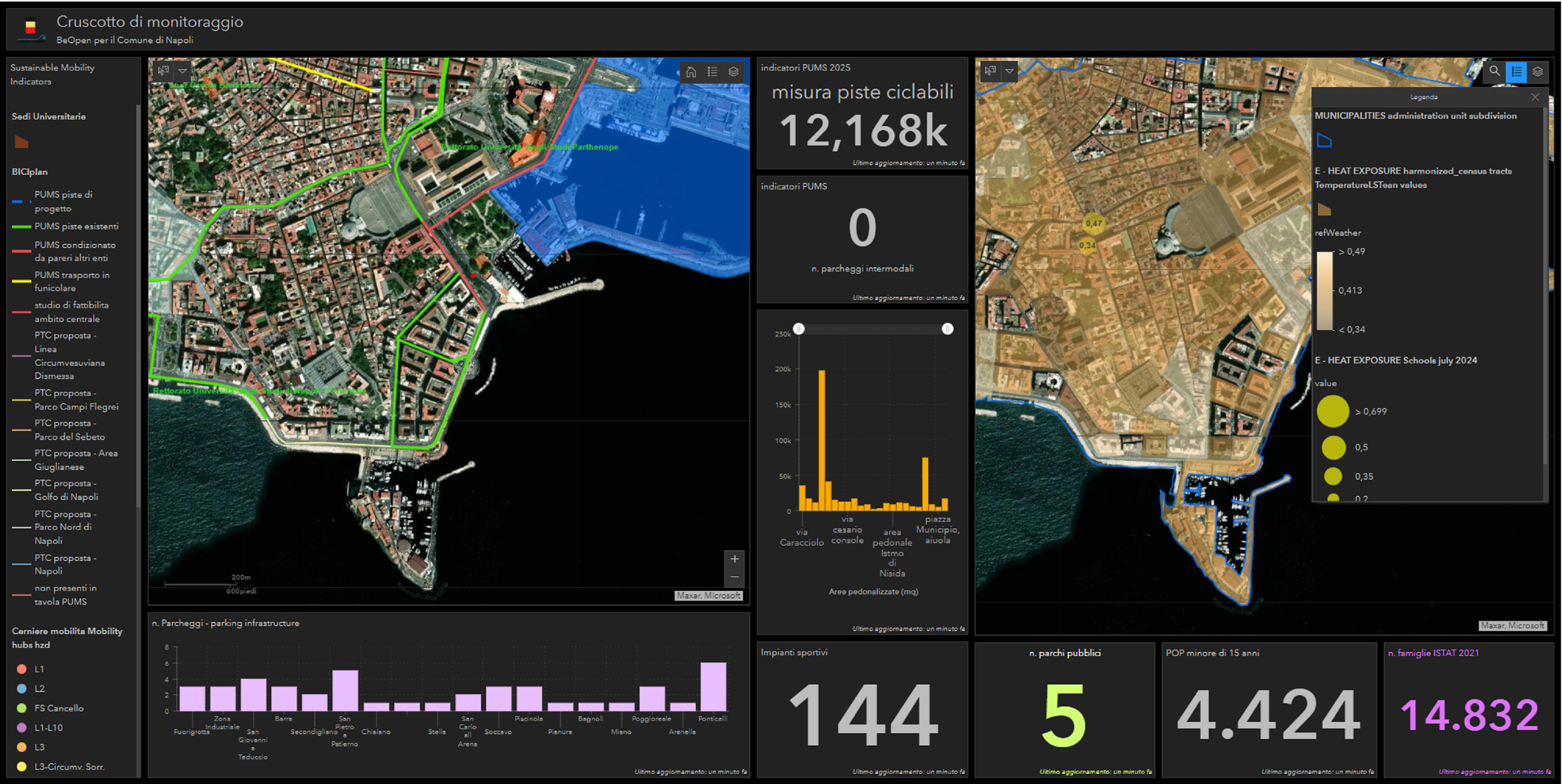
Figure 3: Mobility and green infrastructure dashboard in Napoli, Italy
The city uses satellite imagery and high-value datasets to monitor shared mobility, cycle lanes and green infrastructure, supporting more sustainable urban planning.
Porto: predicting and preventing floods
Flooding poses a serious threat in Porto. Until recently, emergency response teams relied on delayed, external data. With support from the BeOpen project (see further down), the city developed a machine learning model to predict floods and a real-time dashboard to guide emergency services.
The system combines live weather data, traffic conditions and the geolocation of police and fire crews. After deployment, more than half of the city’s emergency responders and planners reported using geospatial data more frequently to monitor conditions and guide decision-making, and data quality scores jumped from 0–70 % to 100 % across key sources like CCTV, meteorology and tree coverage.
Porto Digital, the city’s municipal innovation agency, has shared several high-value datasets.
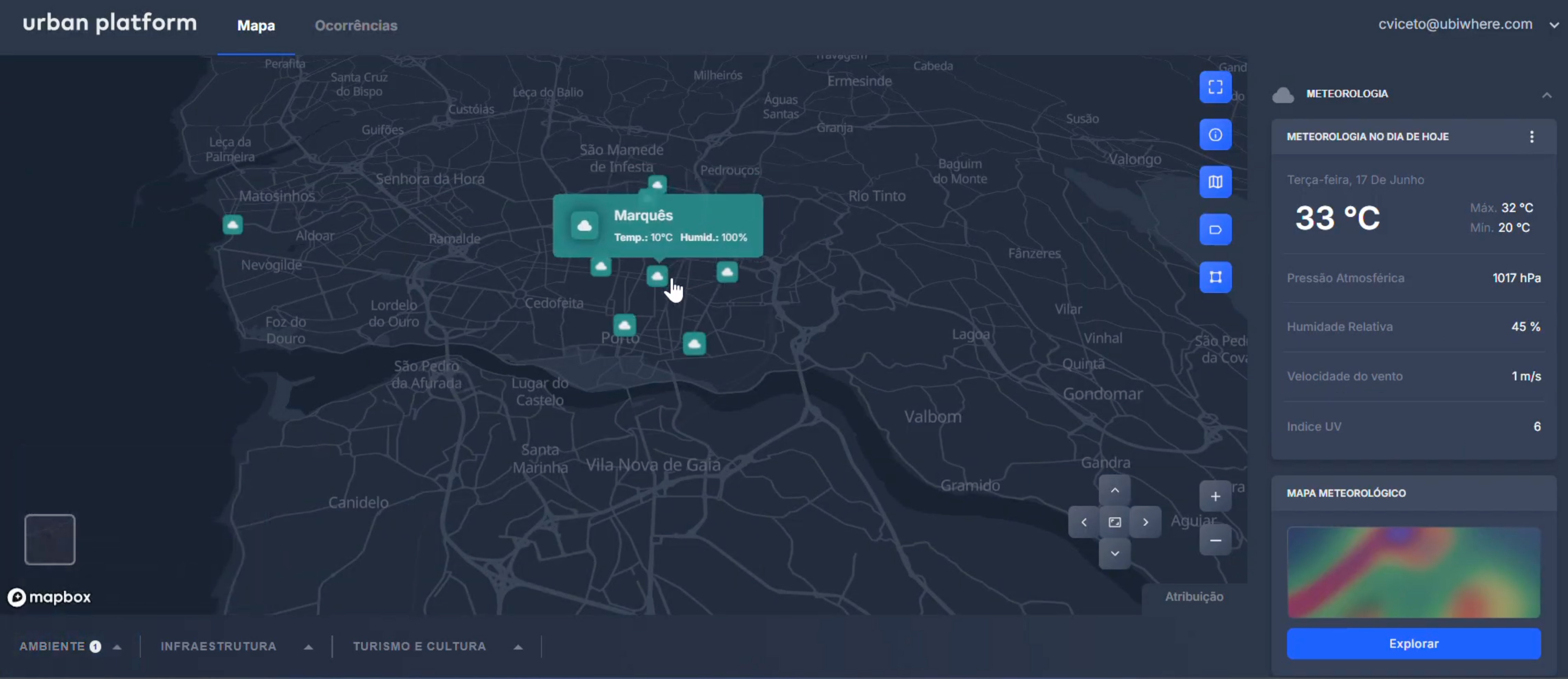
Figure 4: Urban platform in Porto, Portugal
The dashboard integrates real-time weather, traffic and emergency services data to forecast floods and support rapid response powered by high-value datasets and machine learning.
From pilots to policy: what cities can learn
The four pilots featured in this story were developed as part of the EU-funded BeOpen project, which supports cities in using high-value datasets to address urban challenges.
Lydia Montandon, Community Outreach Coordinator at the FIWARE Foundation, a non-profit organisation and member of the BeOpen consortium, said: ‘Digital tools and better data quality can improve the delivery of public services. By making high-value datasets more accessible and reliable, the BeOpen project has helped participating cities enhance decision-making and service provision and offers a model that others could build on.’
These examples show how public data, when opened and improved, can drive smarter, faster decision-making in European cities and regions. Whether it is by protecting citizens from wildfires, forecasting floods, managing traffic or improving green infrastructure, the reuse of high-value datasets is unlocking new levels of urban resilience and helping deliver better public services across Europe.