The opportunities of sharing cross-border geospatial datasets
Why and how can open geospatial datasets benefit our society, environment and economy
Geospatial datasets as open data
Geospatial datasets is information that contains specifications on properties that are linked to an exact point on Earth. Examples of geospatial datasets include satellite imagery, as well as census datasets tied to specific geographic areas (Open Data Maturity, 2022).
Facilitating the discovery and access to open geospatial data sources is an essential goal for data.europa.eu. We will guide you through the importance of publishing geospatial datasets under an open license in view of the recently adopted high-value datasets implementing regulation, and with examples on how such data can have an impact on our daily lives.
Zooming into the high-value datasets implementing regulation
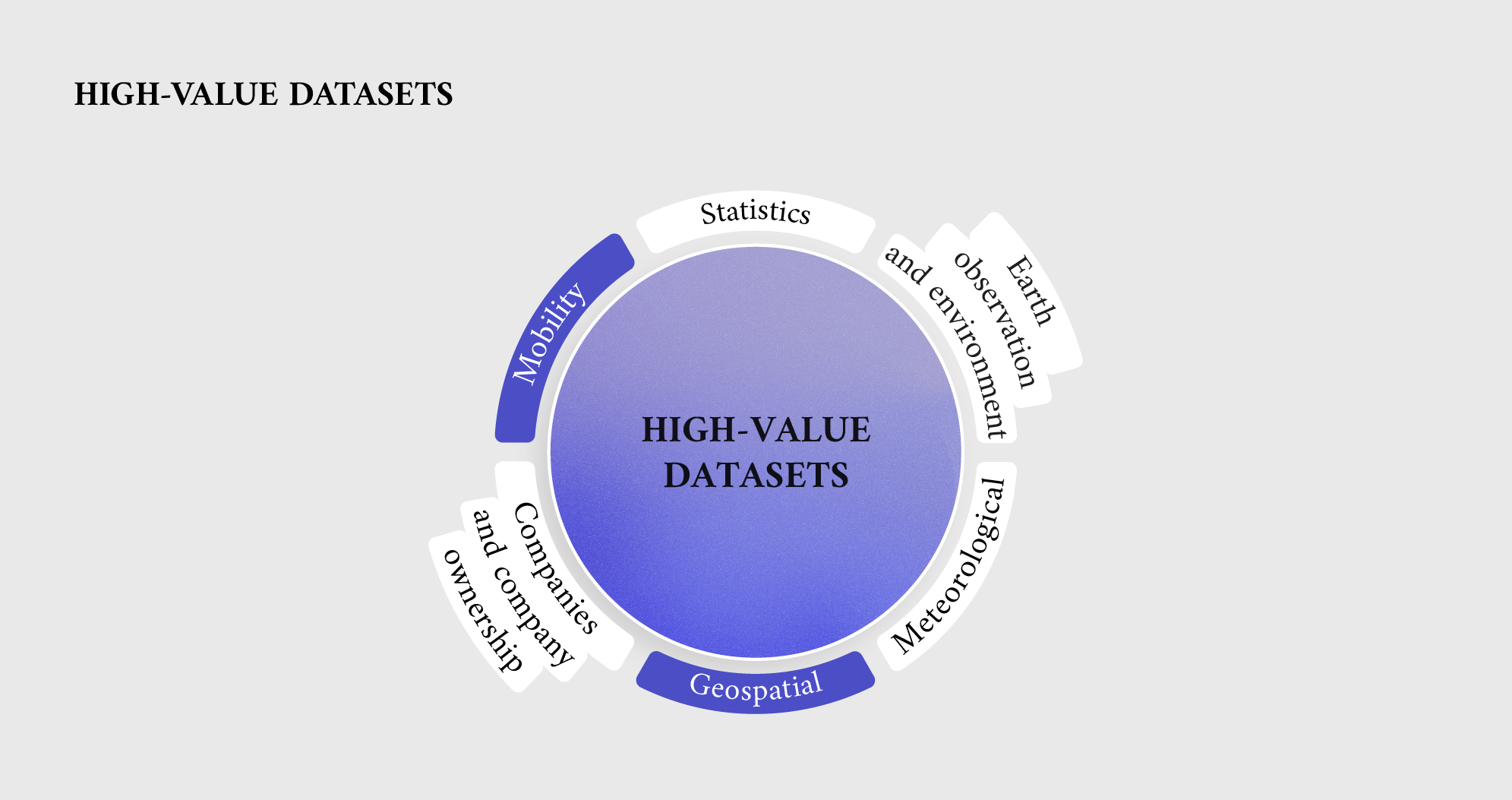
The European Commission adopted the high-value datasets implementing regulation on 21 December 2022 and published it on 20 January 2023. The legislation lays down a list of specific datasets (Annex 1) providing important benefits for society, the environment, and the economy. This list is based on six thematic categories already explained in our previous data story:
- geospatial,
- Earth observation and environment,
- meteorological,
- statistics,
- company and company ownership,
- mobility.
More specifically, the implementing regulation sets out requirements on the formats in which these datasets have to be published and reused (articles 3 and 4). Public sector administrations in EU countries must comply with these requirements and make their datasets available in the formats specified by June 2024. In addition, according to article 5, they are expected to submit a report to the European Commission in 2026 detailing the actions they have taken to put the implementing regulation into effect.
When it comes to publication, public administrations need to publish the high-value datasets in machine-readable formats via Application Programming Interfaces (APIs) and, where indicated, also as a bulk download. Together with the APIs, publishers are required to provide terms of use and the quality-of-service criteria on performance, capacity and availability. Moreover, terms should be available in a human- and machine-readable format within the EU or internationally. Furthermore, public bodies are required to designate a point of contact for questions and issues related to the API and to denote high-value datasets as such in their metadata, i.e., in their description.
When it comes to fostering data reuse, the regulation also applies to high-value datasets created before its adoption. These datasets should be made available for reuse under the conditions of creative commons licenses (e.g., the Creative Commons Public Domain Dedication (CC0) or the Creative Commons BY 4.0), or any equivalent open licence, allowing to dedicated rights of a work to the public good.
Geospatial high-value datasets on data.europa.eu
Among the six thematic categories of datasets listed in Annex 1, there are three areas connected with geospatial datasets already in the scope of the INSPIRE directive, improving the availability and accessibility of relevant geodata since 2007:
- The ‘geospatial’ category clusters seven datasets themes: administrative units, geographical names, addresses, buildings, cadastral parcels, reference parcels, as well as agricultural parcels.
- The ‘Earth observation and environment’ category refers to Earth observations, including space-based or remotely sensed datasets, as well as ground-based or in situ datasets, environmental and climate datasets.
- The ‘mobility’ category contains the datasets theme ‘Transport networks’ (as defined in Annex I to the INSPIRE directive), which may include geographical positions and links with cross-border networks.
At data.europa.eu, we acknowledge the importance of geospatial datasets as high-value datasets and continuously work to boost both the reuse and supply of these datasets across Europe. Over the past two years, data.europa.eu team has organised three webinars on the topics of 1) geospatial data, 2) harvesting of this data, and 3) related trends, and has released several publications on the matter. The latest one, ‘Geospatial trends 2022’, was published in December 2022, following the dedicated webinar. The report highlights the opportunities available to data.europa.eu from two emerging trends in the geospatial community. The first one is high-value datasets as an opportunity to support the work so far done by the INSPIRE directive and give further impetus to its modernisation. The second refers to the importance of geospatial references for the development of smart city solutions. Some examples would be geospatial base datasets (e.g., background maps), traffic datasets (car counts, person counts, traffic lights, parking spaces, bike sharing, etc.), public transportation datasets (real-time schedules, delays, and disturbances, etc.), environmental conditions, lighting, utility network datasets, or 3D models.
Besides these resources, data.europa.eu is the point of discoverability for more than 4 000 geospatial datasets such as examples of high-value geospatial datasets key to smart city projects. As a reference, a smart city is a place where traditional networks and services are made more efficient with the use of digital solutions for the benefit of its inhabitants and businesses (European Commission).
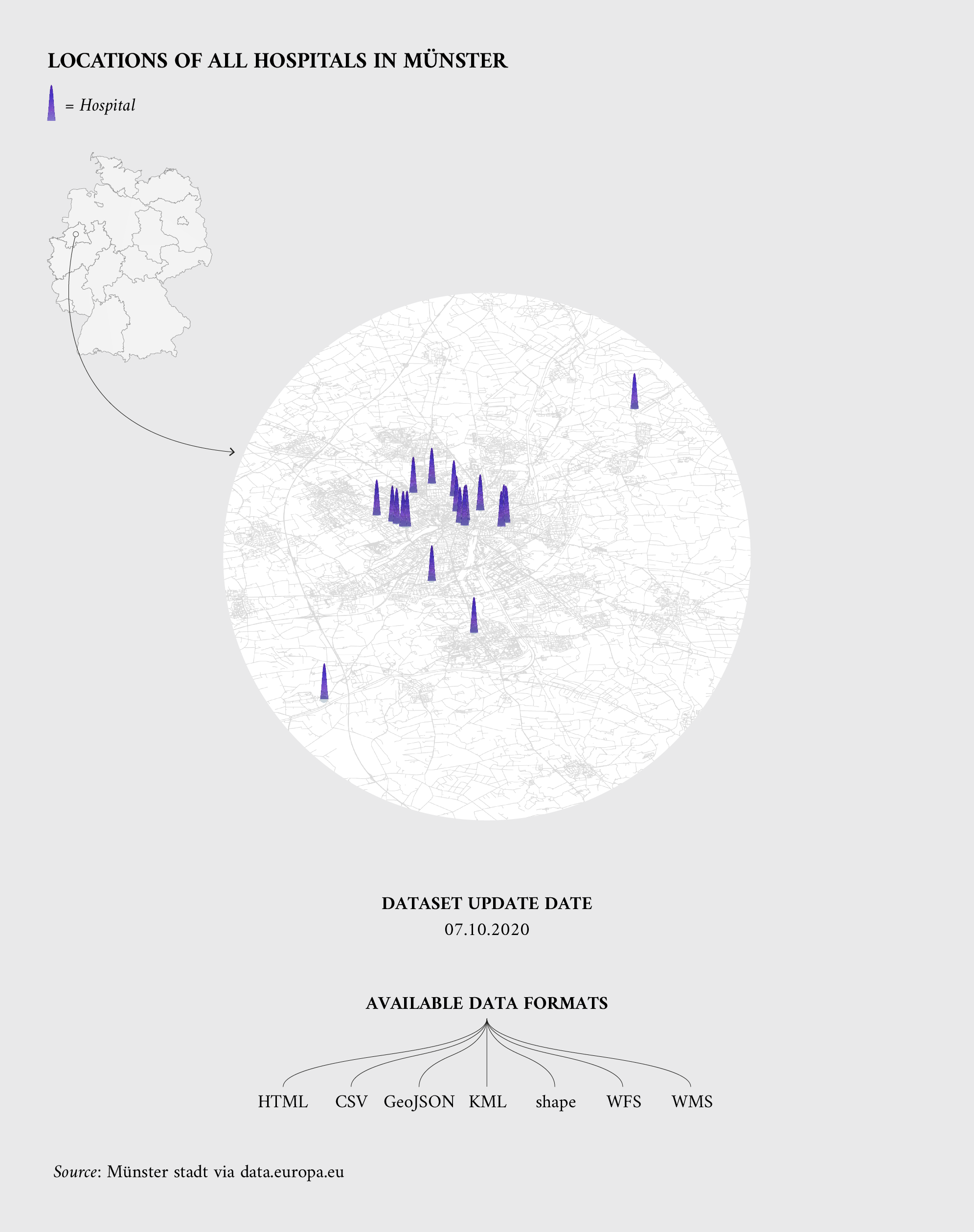
Examples on geospatial datasets for hospitals and administrative units and categorised as ‘geospatial’ in the high-value datasets implementing regulation
- Locations of hospitals: This dataset, by GovData Germany, contains the locations of all hospitals in the municipality of Münster (Germany) in various machine-readable formats. This includes the names, the geocoordinates, the addresses and a link to the homepage
- Nls-FI INSPIRE Administrative Units: This dataset, by Open Data Finland, depicts administrative units covering the land area and maritime units covering the sea area of Finland.
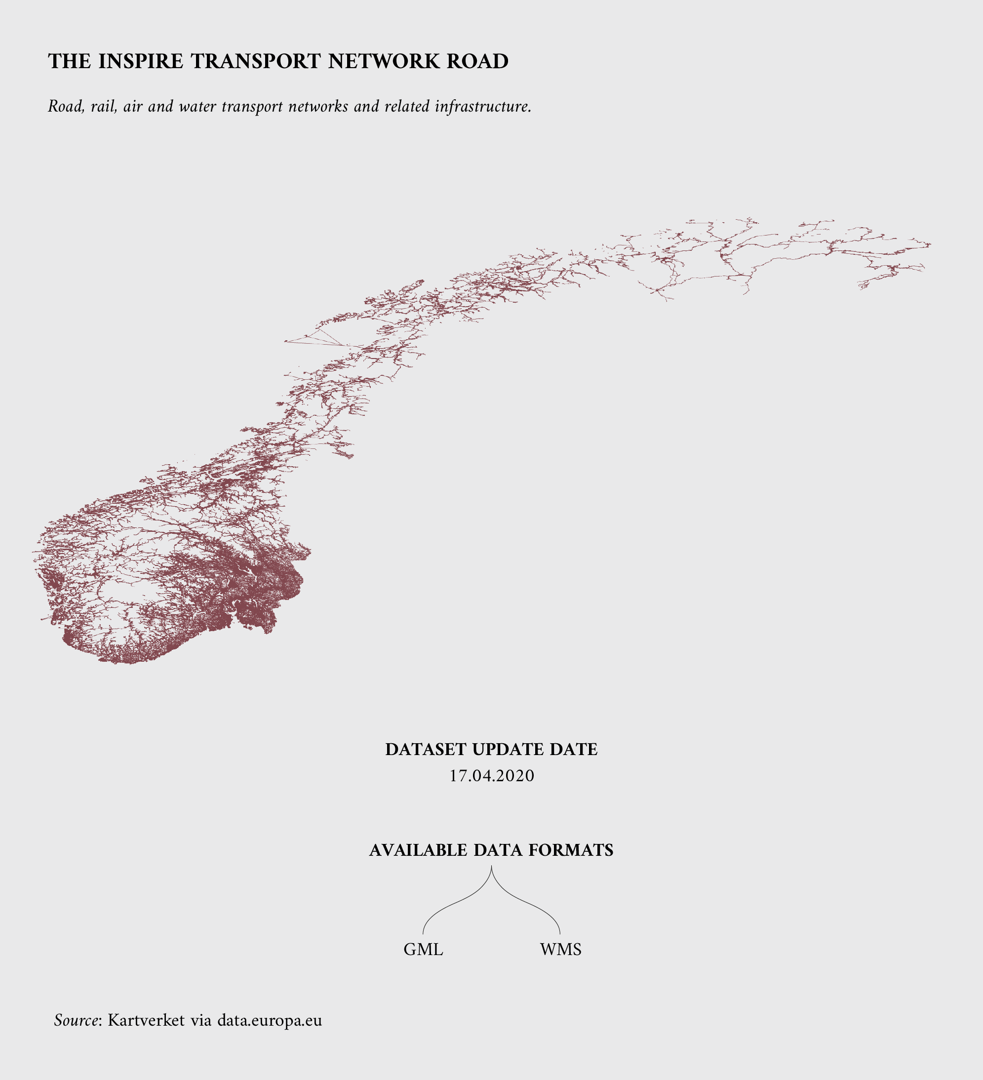
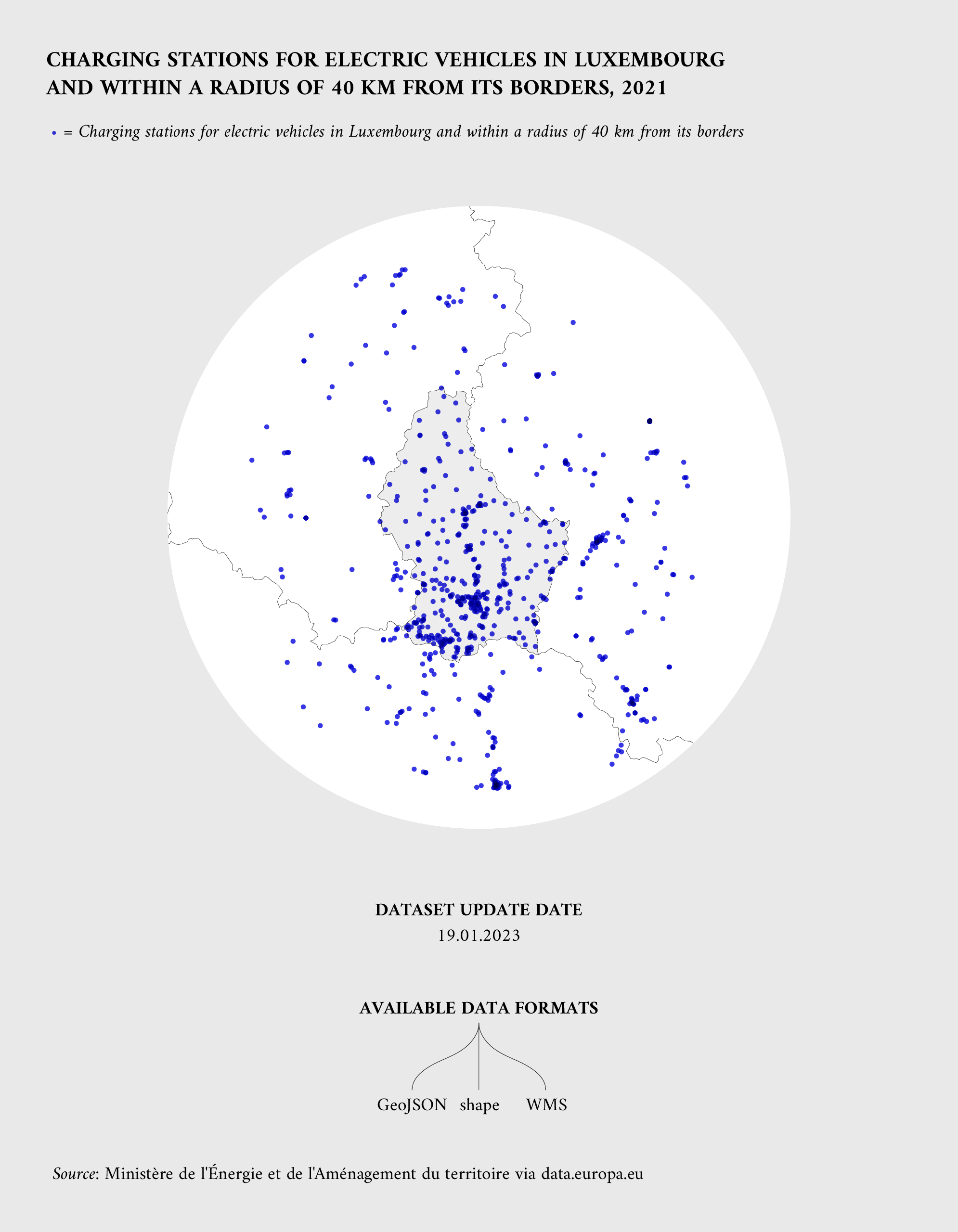
Examples on geospatial datasets for smart cities’ services and categorised as ‘mobility’ in the high-value datasets implementing regulation
- Inspire Transport Network Road: This dataset, by data.norge.no (Norway), reports road, rail, air and water transport networks and related infrastructures, including the links between these different networks.
- Charging stations for electric vehicles: This dataset, by la plateforme de données luxembourgeoise, shows the location of charging stations for electric vehicles in Luxembourg and within a radius of 40 km from its borders.
Reuse cases based on high-value geospatial dataset
Several public and private organisations across Europe already use datasets that brings added value to society, economy, and environment. Some examples were collected in the data.europa.eu first report of the Use Case Observatory, and showed the importance of these high-value datasets to create these innovative services and products:
- 3D City Model contains high-value datasets on buildings, part of the ‘geospatial’ category. The Danish Agency for Data Supply and Infrastructure and the municipality of Aarhus have developed a prototype of the entire municipality of Aarhus to investigate what is possible with a modern object-based 3D city model. The city model pilot in Aarhus uses geo datasets from Geo Denmark as its main source and these datasets is openly available. Datasets from Denmark Footprints is used for the energy consumption of buildings and datasets from Pointcloud is used to get the height of a buildings.
- EVapp has datasets that fall into the ‘geospatial’ category of high-value datasets due to the address locations. This Belgian app uses OpenStreetMap to help locate victims of cardiac arrests and first aiders in proximity. It maps the locations of all automated external defibrillators (AEDs) in Belgium, provided by the government and local cities.
- Digital Forest Dryads contains high-value satellite imagery datasets in the category of ‘Earth observation and environment’. It uses open satellite imagery to protect forests from illegal deforestation in Romania and other EU countries. These datasets comes, among others, from the European Commission’s Directorate-General for Defence Industry and Space and from the Copernicus programme. To learn more on the topic of forests and orthoimagery, you can read our data story ‘High-value datasets – forest fires in the EU’. The Romanian app won the first prize in EU Datathon 2020 for the category ‘European Green Deal’.
The future of geospatial high-value datasets on data.europa.eu
With the publishing of the high-value datasets implementing regulation and the INSPIRE directive, geospatial datasets will become even more central for Europe and for data.europa.eu. The portal will improve this area by continuing to foster the publishing of dynamic datasets and geodata via APIs, as well as by further investigating ways to support finding and accessing high-value datasets.
In a similar way, the increasing availability of datasets resulting from new smart city services is an important trend for data.europa.eu. The portal could foster the discoverability of smart city resources via data.europa.eu, as well as the continuous monitoring of reuse cases based on geospatial datasets positively impacting our society, environment, and economy.
Extending the features of data.europa.eu to allow our community to benefit from and support new ways of sharing geospatial datasets has also been taken into consideration. Some of these improvement ideas directly came from our community, who participated in the data.europa academy webinar ‘Geospatial Trends’.
For more information on these suggestions and insights into geospatial data trends, you can read the related report-out, ‘Geospatial Trends 2022’. A 2023 version of the webinar and report are foreseen for the second half of the year.
For more information on high-value datasets, don’t miss out the data story series dedicated to these datasets.